markers » Page 2 » Custom Developer Tools and VCL Components | Developer Team

TMS FNC Maps v1.2.1.0 for Delphi 10.4 Sydney Cracked

TMS FNC Maps v1.2.1.0 for Delphi 10.4 Sydney Cracked


Hold the full power of mapping in your hand! Cross-framework, cross-platform, cross-service mapping component library.

Directions/Routing (TTMSFNCDirections)
Options for configuring alternative routes, step by step directions, …
Geocoding (normal, reverse) (TTMSFNCGeocoding)
Getting current location (TTMSFNCLocation)
Getting elevation for a location (TTMSFNCElevation)
Read more

X-Files X-DBGrid v7.4 Component Package for Delphi 10.4 Sydney Cracked

X-Files X-DBGrid v7.4 Component Package for Delphi 10.4 Sydney Cracked


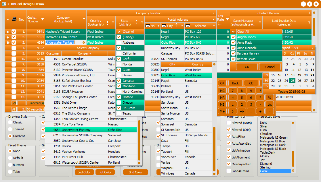
TXDBGrid component is a powerful functional extension of standard TDBGrid component. TXDBGrid component looks beautiful and implements many additional features like: fixed columns, Windows themes and custom styles, many variants of gradient drawing, proportional scrolling for any DataSet even filtered, expandable columns and title headers, checkboxes, hot buttons, title and indicator images, many variants of pictures drawing into cells, sorting markers and multicolumns sorting, enhanced lookup list, data list, calculator, calendar, storing and loading columns layout, enhanced support for bdRightToLeft BiDiMode, extended rows, columns and cells selection, auto-number and auto-select column, hints and tooltips, column stretching and many, many more ...
Read more

TMS IntraWeb WebOSMaps v1.5.1.0 Full Source

TMS IntraWeb WebOSMaps v1.5.1.0 Full Source


Position markers can be added to the maps. Markers can be default balloons or custom images.
Markers is a collection of positions that are indicated on the map. Markers are based on longitude and latitude coordinates.
A custom label text can optionally be displayed on top of a Marker, polyline or polygon or anywhere on the map.
Polylines is a collection of lines that are displayed on the map. Polylines are based on a list of longitude and latitude coordinates.
Read more